|
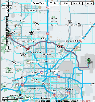
Travel 43.1 miles, about 48 mins, up to 1 hour in traffic
These directions from Google Maps are for planning purposes only.
You may find that construction projects, traffic, or other events may
cause road conditions to differ from the map results. |
Start at the Denver International Airport
8500 Pena Blvd, Commerce City, CO |
| Turn |
Distance |
Time |
| 1. Head south |
0.9 mi |
2 mins |
| 2. Slight left at Pena Blvd |
0.2 mi |
|
3. Slight right to stay on Pena Blvd
(signs for Rental Car Return/I-70/Airport exit) |
3.3 mi |
3 mins |
4. Take exit 6B for E-470 Tollway N
(toward Fort Collins |
0.9 mi |
1 min |
| 5. Merge onto E-470 N (Toll road) |
18.0 mi |
16 mins |
| 6. Continue on NW Pkwy W (Partial toll road) |
8.6 mi |
8 mins |
| 7. Continue on Storage Tek Dr |
0.4 mi |
|
| 8. Turn right to merge onto US-36 W |
9.5 mi |
12 mins |
| 9. Turn left at Canyon Blvd |
1.3 mi |
4 mins |
| 10. Turn right at 9th St |
364 ft |
|
End at the St. Julien Hotel
900 Walnut St., Boulder, CO |